


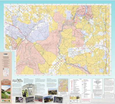
Owyhee Canyon Country Map
$19.95
Get out and explore the beautiful regions of the Owyhee Canyon Country with this easy-to-use foldable map!
This map is part of the Pacific Northwest Recreation Map Series which provides information on recreational uses, trails, roads, streams, lakes, visitor centers, facilities available, campgrounds, picnic areas, other cultural features, and may include shaded relief. Each map covers all or part of one national forest, and is mapped at a scale of 1/2 inch per mile (1:126,720). Pacific Northwest Recreation Maps usually cover a larger area than the Forest Visitor Map it replaces, including more adjacent federal lands such as Bureau of Land Management, National Park Service, or US Fish & Wildlife Service lands.
Covers: BLM Vale District
-
Product DetailsScale: 1/2 inch per mile (1:126,720)Version/Publication Date: 2023Regions: Owyhee Canyon Country, Oregon, USAMedia: PaperFormat: FoldedAdditional DetailsDescription: Good for: Backroading, Camping, Hiking, Hunting, Off-roading, and more!Height In Inches: 36.000Length In Inches: 47.500Two Sided: YesLanguages: English
-
Be the first to review “Owyhee Canyon Country Map”
You must be logged in to post a comment.


Reviews
There are no reviews yet.