


The Northwest Nature Shop’s Ashland, Oregon Trail Map
$0.00
For detailed trail descriptions and maps use 100 Hikes in Southern Oregon by Bill Sullivan or Where the Trails Are by Bill Williams. The best map to Ashland and Applegate Lake trails is the Southern Oregon Map from TreadMaps which also features brief trail descriptions and is waterproof. These and many more local maps and books are available at the Northwest Nature Shop.
This map is free, you will only be charged for shipping and handling.
-
The Northwest Nature Shop’s Ashland, Oregon Trail Map
A fantastic resource when visiting our beautiful region. So much to explore!
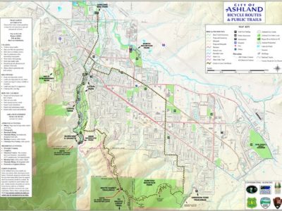
Key to popular trailheads
H = Hiking
HS= Horses
B= biking
W = wildlife watching and Birding hotspot
1. Lower Table Rock; H, 5.2 miles round trip (no dogs)
2. Upper Table Rock; H, 2.8 miles round trip, (no dogs)
3. Denham Wildlife Refuge; W ponds at Oregon fish and Wildlife Office
4. Agate Lake Co. Park; W birding area
5. Jacksonville Woodlands; H, B many trails behind Britt gardens
6. Jefferson Nature Center/Bear Creek Greenway; interpretive trails in the US Cellular Community Park and access to the Bear Creek Greenway which is a 16 mile paved bike path between Ashland and Central Point.
7. Prescott Park/Roxy Ann Peak; H, HS, B, upper road closed during winter
8. Willow Lake Co. Park; B
9. Mt. McLaughlin; H, 10.6 miles round trip, strenuous
10. Grizzly Peak Trail; H, HS, B 5.4 mile loop follow signs from shale city rd.
11. Lynn Newbry Park/Bear Creek Greenway; H, B, W, birding at ponds ¼ mile south.
12.Bear Creek Greenway/Ashland Pond; H,B,W, Parking at Ashland Dog Park, for birding at Ashland pond stay on W. Nevada then right on Glendower to end.
13. North Mountain Park; H, W interpretive trails and classes near bear creek.
14. Upper Lithia Park/Ashland Loop/BTI; 3 trailheads within 100 yards. Lithia Park woodland trails H, 1.2 miles to Ashland Plaza, begin at swim reservoir. BTI trail (H, HS, B) is a 2 mile loop and accesses the Creek to Crest route (a 13 mile route from Ashland creek to Mt. Ashland and the Pacific crest trail) BTI Trail Starts at a small gated dirt road above the reservoir off of Glenview. Ashland Loop Road/ Road 2060; H,HS,B is a 28 mile dirt road loop through the Ashland watershed and accesses trails like Hitt road and Horn Gap. Stay on Granite St. past the reservoir 100 yards to the parking area on the west side of Ashland creek, Ashland loop/ 2060 winds uphill from here. To reach the SE end of the Ashland loop road, as well as the White Rabbit trailhead, turn back toward Ashland on Glenview, Ashland Loop road is the next thru road (1/2 mile) on the right.
15. White Rabbit Trail; H, HS, B 2.2 miles thru Siskiyou mountain Park to Oredson Todd Woods trailhead or to Park St. Caterpillar trail continues uphill 1 mile to toothpick trail. Alice in Wonderland trail goes downhill toward BTI trail.
16. Oredson Todd/Siskiyou Mt. Park; access to trails in Oredson Todd Woods and Siskiyou Mountain Park, White Rabbit Trail (bikes OK) and Mike Uhtoff Trail (hikers only)
17. Toothpick Trail; H, HS, B .8 mile to catwalk trail or 1.5 miles to Ashland Loop road/caterpillar trail. Trail starts on private land so be respectful.
18. Four Corners; H, HS, B, Tolman Creek road intersects with road 2060/Ashland Loop road, strait ahead (NW) rd. 2060 leads to a 10 mile flat section then drops to West side of Ashland Creek, 2060 to the right drops 2.8 miles to white rabbit Trailhead, Catwalk trail starts at parking area and drops 2 miles to toothpick trail, road 200 on left goes up 4 miles to Bull gap trailhead.
19. East view Trail; H, HS, B 2.4 miles to road 2080
20. Emigrant Lake; W and swimming, boating, access to (Free) day use areas on roads past the turnoff to County Park.
21. Hyatt Lake; viewing area midway through a excellent bird watching loop that takes in Emigrant, Little Hyatt, Hyatt and Howard prairie Lakes.
22. Soda Mt. /Hobart Bluff; H, HS Access to Pacific Crest Trail (PCT) and Soda Mountain Wilderness
23. Pilot Rock; H,HS 1.4 miles to base of pilot rock, access PCT for longer hikes in Soda Mountain Wilderness (rough road).
24. Bull Gap Trailhead; H,HS,B 2.5 miles to Mt. Ashland Ski Area, trail back toward Ashland begins 50 yards down rd 2080 on the left (W).
25. Grouse Gap Shelter; access to Pacific Crest Trail H, HS, W great wildflowers.
26. Wagner Butte trail; H, HS, 5.2 miles to summit
27. Sterling Ditch trail; H, HS, B, 17 mile trail along historic mining ditch
28. Mule Mtn. trail; H, HS, B 1.5 miles to mule creek,10.6 mile loop -
Be the first to review “The Northwest Nature Shop’s Ashland, Oregon Trail Map”
You must be logged in to post a comment.


Reviews
There are no reviews yet.